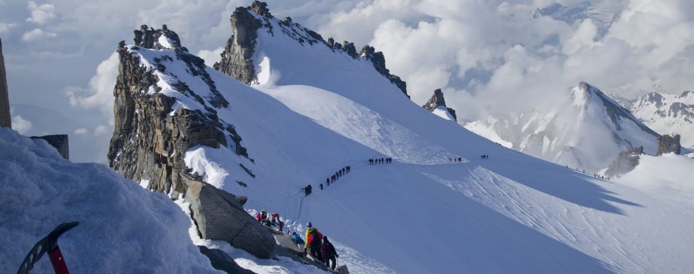
The Italian 4000er that's popular with mountaineers and skiers alike
Gran Paradiso is the highest summit of the Graian Alps which lie between Mont Blanc to the north and Dauphiné range to the south. It is not prominent from the closer valleys, being hidden behind its surrounding mountains. Only from distant summits is its impact obvious. The name arouses concepts of a tremendous unscathed world — easily imagined in this area with its dreamy cirque lakes and lonely screes and snows, with occasional views of the prehistoric-like herds of ibex. However, although this quality can be discovered around the peak it is singularly absent in the valleys and on the mountain’s Normal Route — a popularity ensured by the ‘National Park’ publicity tag. What one finds on the peak is a busy, well-trodden track up one of the ‘easy’ 4000ers. This reputation guarantees its ascent by climbers with a wider age range than is usual on mountains of this height.
Despite the popularity its ascent is far from effortless. It demands over 2000m of height-gain from the car-park at Pont to the summit, and all of this must be made on foot. The first ascent was made by John Jermayn Cowell and W. Dundas with the guides Michel Payot and Jean Tairraz in 1860. They did not have the advantage of the hut, named in honour of Vittorio Emanuele II to commemorate his founding of the national park.
Hut climb from Pont: A broad path heads up the valley and soon drops down to a stream descending in waterfalls on the left (east). Then ascend the valley slope in wide bends through the wood. Continue over sparse pastures and moraines to the barrel-shaped Vittorio Emanuele II Hut (2775m; CAl, 143B, winter room with 43B, mostly overcrowded, managed from the end of April to 25 September, Tel. 0165-95920). Alternatively, from 2km below Pont (camping/car park) take a path to Rifugio Chabod (2750m. CAl, 100B, Tel. 0165 905798).
Summit climb by the West Face: From the hut, head north-wards over the ‘block field’ (very tiresome in the dark) to the moraines leading up to the Gran Paradiso Glacier. Follow these and then a small valley climb over snow keeping below the now receded glacier snout. Instead of going up this (old way) follow cairns to the left of it and then up steep and unpleasant rock and scree to the lower part of the ridge. Go up this to where it narrows (Eselsrücken) and leads along the edge of the glacier to the saddle in front of the pinnacle Becco del Moncorvé towering up on the right at the edge of the south cliff. From the Chabod Hut go along the northern edge of the Ghiacciaio di Laveciau until the glacier can be gained. A south-easterly line is taken to join the Emanuele route at the Eselsrücken. Now ascend north-wards over the steeper slopes, below the rock ridge of the ‘Roc’ to the rimaye. Cross this (usually without problems) and go up a short rocky ridge, with a final surprisingly exposed section (I) to gain the fore-summit (Madonna). The highest point, which lies behind at the north-west end of the summit ridge, may be reached by more rock climbing (II and I) in about 15 minutes.
View: To the north-west the Mont Blanc massif can be seen, to the north-east the Pennine Alp frontier crest, to the south-west the Dauphiné with the Barre des Ecrins and to the south Monte Viso. There is a fine view down the East Face.
Adjacent peaks: The Madonna summit (c.4058m) is only a little lower than the highest point. The Central Summit (c.4015m), also crowned with several rock pinnacles, is quickly and easily climbed from the Normal Route (II and I). The same goes for the somewhat more difficult (II) East Summit (Il Roc 4026m) rising on the connecting ridge. The Piccolo Paradiso (3923m) rises on the ridge running northwards from the main summit.
Other worthwhile routes: East Face (AD, II, mixed and 50°; 900mH from the Pol Bivouac).
North-West Face (D, ice or snow 50°, 600mH from the rimaye).
North Ridge intégral (D, IV and III, 1700mH, 15 hrs from the Leonessa Bivouac).
‘Paradise Found’, by James Thacker (T&M issue 41, Jul/Aug 2013)
‘Reader Report, by Richard Turner (T&M issue 33, Oct 2012)
Map: IGC 1:50,000 No.62003 Gran Paradiso.
Guidebook: Graians East (West Col, 1969).
Travel: By rail through the Aosta valley to Sarre, 6km west of Aosta. By bus up the little road branching off the main road at Villeneuve, 11km west of Aosta, 25km southerly through the Val Savaranche to Pont (1945m, hotel/camping/big car-park).
Hut climb from Pont: A broad path heads up the valley and soon drops down to a stream descending in waterfalls on the left (east). Then ascend the valley slope in wide bends through the wood. Continue over sparse pastures and moraines to the barrel-shaped Vittorio Emanuele II Hut (2775m; CAl, 143B, winter room with 43B, mostly overcrowded, managed from the end of April to 25 September, Tel. 0165-95920). Alternatively, from 2km below Pont (camping/car park) take a path to Rifugio Chabod (2750m. CAl, 100B, Tel. 0165 905798).


