


You haven’t seen the world until you’ve seen the Isle of Skye. Edge your way through the Highlands, pass the magnificent peaks of the mainland and the beauty of the glens, and the miles of coastline shining in the northern sunset; you’ll think you’ve discovered all the wonders of Britain’s ancient peaks… and then you cross the bridge.
Skye combines great beauty with a healthy disregard for what you’d usually assume are typical mountain shapes. Thrown up in ridges, clumps and huddled groups, mountains the shape of spear-tips stand shoulder to shoulder with those that look like giant termite nests, or the half-buried heads of Moomins. The island’s 400- mile coastline is a constantly changing stage of cliffs, beaches, and the occasional marsh, where seals bask on the rocks, sea eagles hunt over the waves, and, far out you can glimpse the fins of whales.
It is an island of several names; An t-Eilean Sgitheanach (The Winged Isle), Eilean a’ Cheò (The Misty Isle), and of course the Isle of Skye, possibly from the Celtic Skitis, also meaning ‘winged’. This refers to the way the various peninsulas spread out from the core of the island, like a great eagle taking flight.

Admiring the distinctive pillars of the Old Man of Storr
The Skye Trail
If you are thrown for how to spend a week in such
a contrasting landscape, then there’s a way to experience the island by linking together the most striking parts. Recently described, wonderfully ‘unofficial’ and with days that vary from gentle ambles along pretty coastline to serious mountain journeys over near-pathless terrain, the Skye Trail is, once known about, impossible to ignore.
Running roughly 80 miles from the most northerly point on the island at Rubha Huinish, the trail vaults over the Trotternish ridge, bounds past Portree, dives straight through the Red Hills and the Cuillin, and after spending wistful miles along the southern coast, throws you out in Broadford a new person. For most sections, average fitness is fine, though there is one very committing day over the Trotternish ridge which could easily take 10 hours, and one or two exposed paths where care is definitely needed. Wild camping will mean you won’t have to worry about catching buses, but if you are well organised you can easily stay in B&Bs every night.
The trail itself was devised in fits and starts by a series of walkers. The photographer David Paterson documented a then unnamed walk through Skye in the ‘90s, followed up by the writer and broadcaster Cameron McNeish’s journey along most of the same line in the late 2000s. Since then, many others have taken it under their belt, most notably Helen and Paul Webster in their guidebook for Cicerone Press. The suggested route has changed in several sections, whipping from side to side, refusing to be pinned down, as various writers battled with what was the most logical route over Skye’s nefarious terrain. The northern section has swapped coasts, and the most southerly terminus has changed locations, preferring the abandoned railway line to Broadford over the vast bogs of Sleat. Even the heart of the route through the Cuillin has various options; do you go straight through Glen Sligachan, over to Loch Coriusk, or up Blabheinn?
This article gives a snapshot of what might be called the most popular route, though I use that term with hesitation. As with any long-distance trail or lengthy undertaking, research the alternatives and decide for yourself what sounds the most attractive. It has traditionally been described as running north to south, though it is, of course, perfectly possible (and often done) to walk from south to north. This gives the added impetus of having Skye’s most northerly point as your final destination, surely a more romantic ideal than Broadford high street.
Alongside the two principal towns of Skye, both of which you pass through on the trail, you will of course encounter a more ancient way of life. Clan castles dot strategic points, names give away the sometimes bloody past, and the remains of the Clearances lie stark on the land. Tread softly on these trails, for these remote hillsides were once home to hundreds more people than live in them today. Take your time to see past the modern tourism on Skye to a land of people who lived close to the land, to myths of the fairy people and the seal people, to forgotten highways and hideaways. This is the unique insight that long-distance walking offers, and it is more than true on Skye.
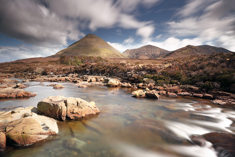
Glamaig (Sgurr Mhairi) and surrounding landscape
Stage 1: Rubha Huinish to Flodigarry
Standing at the most northerly point on the island, looking out over the Sea of the Hebrides while searching for the faintest sign of a whale fluke, is a fine way to start any journey. Getting there requires a short walk from Duntulm, perhaps staying the night before you start in the bothy near the headland, the
old coast guard watch station with fantastic views over the water. From this northerly point the route turns south and runs along the eastern coast of the Trotternish peninsula. Passing the remains of St Moluag’s Church, it picks its way as close to the sea as possible, giving you fine views of wave-dashed rocks and sea stacks. Although the navigation here isn’t tricky due to the general need to ‘keep the sea on the left’, the terrain is pathless. The only bit of path-finding comes towards the end, where the hill of Druim nan Slochd comes into view ahead. Before this hill, there’s a path that leads you in a ramp down the slopes to continue along the top of the cliffs.
Finishing at the Flodigarry Hotel, you have the option of the hotel itself, a nearby hostel, or accommodation in Staffin. Wild campers will probably want to continue towards the Quiraing and find campsites after crossing the main road. Although Flodigarry is the finishing point of this stage, walkers can take the sting off the next day, which is the longest on the trail, by continuing along the section from here to the car park after the Quiraing. This is a remote road though, so make sure you’re either wild camping or have arranged transport from the end.
Stage 2: Flodigarry to The Storr
This stage is by far the most difficult on the Skye Trail. It is a true mountain day, taking you for nearly 30km and with 1,700m of ascent over the Trotternish ridge, reaching several summits on the way and ending at a roadside where onward transport is required. It is a fantastic journey, where on a clear day both coasts of the Trotternish can be seen, as well as Skye’s westerly peninsulas and the first look at the Cuillin in the distant south.
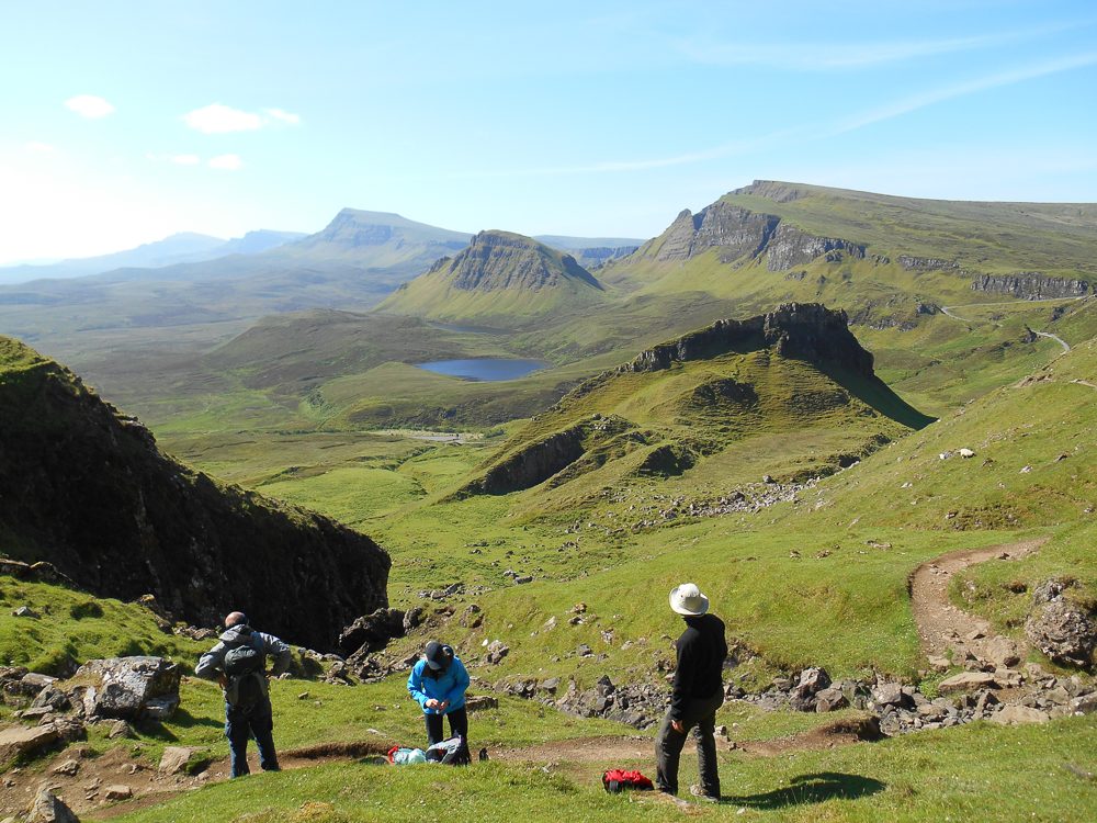
The route begins by climbing up through the debris of the Quiraing after crossing the main road west of the Flodigarry Hotel. The Quiraing’s bizarre rock formations are the result of a giant landslip millions of years old, where weak sedimentary rock was no longer able to support the heavy volcanic rock above. The gigantic hunks of mountain, strewn over the eastern side of Trotternish are your constant companions throughout the day. Once through the Quiraing, the trail gains the main ridge and progresses south along it. The route is grassy and never particularly steep, rolling along for miles ahead. The cliffs of the landslip are always to the east, whereas the western side is a gentler cascade of grassy slopes and deep corries. Not only is this stage long, it is also committing, with the only escape from the ridge several hours walking through open and frequently wet terrain.
Navigating off the final slopes of The Storr can be a little tricky, but the reward is a descent past the rock pinnacle of The Old Man of Storr, one of Skye’s most popular viewpoints. At the end of this lengthy but thrilling roller coaster over the Trotternish peaks, you’ll have well and truly earned your supper!
The start of the coastal path from Elgol to Camasunary, with the Cuillin ahead
Stage 3: The Storr to Portree
A definite reprise after the efforts of the day before, this stage offers a hill with some excellent sea views, and cliffs plunging nearly 400m down into the waves. Starting from the car park beneath the Storr, head to the coast and spend some time at the viewpoint looking out over the impressive Bearreraig Waterfall, plunging from Loch Leathan almost straight into the sea. From here it’s a journey over pathless hillside, south over subsidiary peaks, to reach the summit of Sìthean a’ Bhealaich Chumhaing. The joy of the journey there is to pick your way easily among the crags and enjoy the views east over the Isle of Raasay. Somewhere below this route, and marked on the OS map, is the cave where Bonnie Prince Charlie fled to when he was whisked over the sea to Skye after defeat at the battle of Culloden.
From the main peak of the day, the trail descends to the shore beside a ruined chapel and follows a final pretty stretch of wooded shoreline round into Portree Bay. The coloured buildings on the harbour are a vibrant and welcome objective after three days out in the remote north of Skye. Portree is Skye’s main town, and has all the facilities you could need, especially if you are a wild camper looking to re-stock.
Stage 4: Portree to Sligachan
Leaving the bustle of Portree behind, the beginning of this stage involves a wander along the skirts of Loch Portree, the protected part of Portree Bay where wading birds call among the mudflats. Make sure you check the tide times as at high tide some of this route can be underwater and the only other option is the pavement along the main road.
From the southern end of Loch Portree, it’s quite a way along a road out into The Braes. This is more than made up for by the scenery, and after several off-path miles over the last few days you will cherish some time without looking at your feet. The shapely hill of Ben Tianavaig is the first landmark, followed by an intimate look at the Isle of Raasay, quite close now across the Narrows.
At the end of the road in Peinachorrain, the trail becomes a path once again. With the twin-topped peak of Glamaig ahead, your first close view of the Red
Hills, the route follows the northern shore of Loch Sligachan. This section is a lot of fun and you’ll soon
see the end of the day at the Sligachan Hotel far ahead. Look out for seals in the loch, but be aware that there are a few streams to cross, which after heavy rain can become hazardous.
Beyond the marshland at the head of the loch, the famous hotel is reached. You just need to choose whether to stand astounded at the prospect ahead, the view of the jagged Cuillin and the Red Hills arranged before you, or to dive straight into the bar and sample one of the many hundreds of whiskies on offer. If you’re a camper then this is one of the main campsites on Skye, and worth a stop just for its long running association with mountaineering on the island.
Journeying through the immense landslip debris of the Quiraing
Stage 5 – Sligachan to Elgol
Now begins the journey into the heart of Skye’s mountains, on a day that is up there with the best low-level journeys through mountainous terrain in the whole of the UK. Walking right from the Sligachan Hotel, the view ahead is monstrous and wonderful. On the left, the granite of the Red Hills shines pink in the sun, and on the right, the notched and tumbling ridges of the Cuillin form a black signature to the skyline.
The trail leads straight between these two, down the mighty Glen Sligachan, a popular place to look for golden eagles. The path is easy to follow and the view constantly changes as new peaks appear and perspectives change. The dark gabbro and basalt of the Cuillin, as though fresh from its time as a volcanic magma chamber, looks inaccessible, but stare harder and the figures of scramblers and climbers will doubtless be visible, balancing between the rocks on the famous Pinnacle Ridge of Sgùrr nan Gillean, the first peak you pass.
Passing several lochs, the trail now passes the watershed at the head of the glen and enters Srath na Crèitheach for the slow downhill journey towards the sea at Camasunary. Just when you thought the Cuillin had made their mark, the castle buttresses of Blabheinn comes into view, an outlier of the main ridge that will stay with you for the next day and a half on the trail. Another route to Camasunary involves a detour to Loch Coruisk, though this is longer and requires a crossing of the ‘bad step’ above Loch nan Leachd.
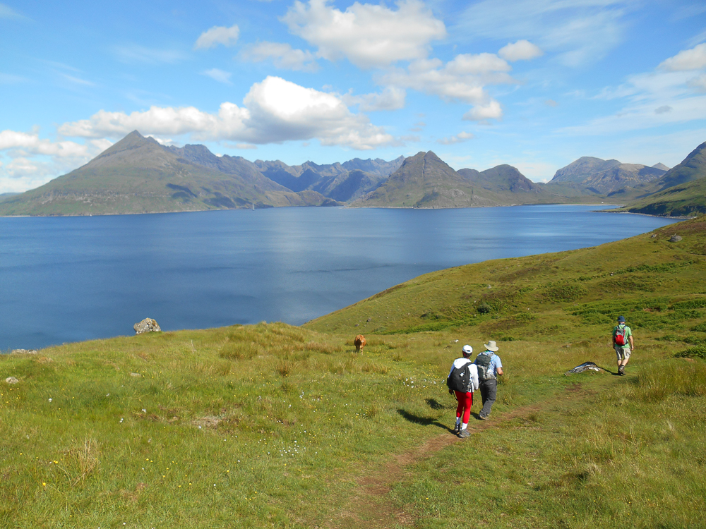
Passing the bothy at Camasunary, the route now follows the coast of Loch Scavaig. This section is often exposed, and care should be taken on some eroded sections of path. Navigation is simple however, and before long, the route deposits you into Elgol, where the view back towards the arms of the Cuillin wrapping around an invisible Loch Coruisk is one of the true classics. If you have any sense at all you’ll return next time to climb these peaks.
Stage 6 – Elgol to Torrin
Beyond Elgol the character of the trail changes again. After a short detour inland, the route reaches the coast at Loch Slapin which is your point of reference for the whole day. Across the water lies the Sleat peninsula, low lying and ground down to bare crag bones, speckled with lochs. The trail heads north, passing the ruins of fortified houses and stone circles, a reminder that this land has been occupied for thousands of years.
Ahead, the view of the Red Hills from the south reveals new peaks. The stately shape of Beinn Dearg Mhòr is offset against the towering bulk of Blabheinn, which though hidden at the start, soon comes into view towards the end of the stage. The last few kilometres are along the road round the head of the loch to reach Torrin, and in general the stage’s frequent transition from road to track and back again, with one nice section of hill-path, makes it a simple one to follow, while not being too hard on the feet.
Torrin has an excellent café, and though accommodation may be sparse there is plenty of space to be found for wild campers in the surrounding glens, or even beside Loch Slapin itself.
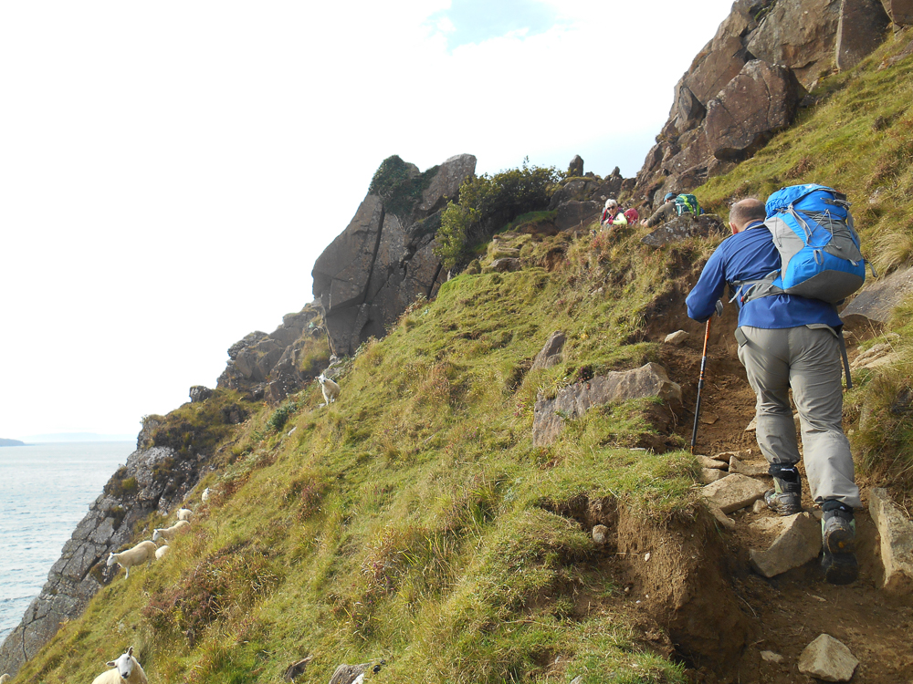
Tackling an exposed section of path along the coast near Elgol
Stage 7 – Torrin to Broadford
Interest doesn’t relent on this excellent final stage of the trail. Following tracks it heads south again, following the coast to Rubha Suisnish, the point of land that divides the sea lochs of Slapin and Eishort, the Isle of Rum a distinctive feature out over the waters. The route then follows the coast as it bends east, taking the path that runs from Suisnish to Boreraig. These two abandoned villages, of which you will see buildings and field outlines, are remnants of the Highland Clearances. These dark days of Scottish history involved the removal of whole communities by lairds who found they could make more money from using the land for sheep. Thousands starved and died, and of those who did not, many fled or were forcibly sent to the New World. This area is notable for the brutality by which the inhabitants were evicted, and the heart-breaking eyewitness accounts that exist.
The path descends right to the shore before climbing past Boreraig on a well-defined route through the pass north to Suardal. Rather than joining the road, the track bends east again and follows the old railway line to Broadford, which used to link the quarry to the town.
Looking out over Broadford Bay at the end of the Skye Trail, the island of Pabay anchored offshore and lying low, there will be much to look back on. Whether you’ve walked for the last seven days in stunning sunshine or lashing storms, you’ll have experienced
the many characters of Skye’s landscape. It is peaceful beach wanders and high mountain journeys all in one, with everything in-between. It is beguiling and never easy to pin down, and there is always more to come back and discover.
5 GREAT SIDE TRIPS
Extend your trip with the following days out..
1. Beinn na Caillich horseshoe
A classic round of three peaks in the Red Hills, and possibly the first mountains you see when you drive onto Skye. An exciting boulder ascent followed by an easy trail with great views.
2. Cuillin summits
The Skye Trail passes right next to Blabheinn, which is accessible from Torrin or Camasunary; alternatively, the trio of northern summits accessible from Sligachan are fantastic prospects. Sgurr nan Gillean is the most striking, but even the easiest way up is a grade 3 scramble.
3. Fairy Pools and Talisker
Out west of the trail, walk out and jump in for a swim in the famous pools, then drive the short distance to the whisky distillery at Talisker. You might even have time for sunset from Talisker Bay.
4. Dinosaur Footprints
Halfway up the Trotternish peninsula lies Staffin; head down to the bay and spend some time searching at low tide for the fossil dinosaur footprints. Even if you’re unsuccessful, the bay is a great place to swim.
5. Way out West
If you have a spare day near the end of your hike, head out west to walk the coral beach, admire the stately Dunvegan Castle, wander to Skye’s most westerly promontory at Neist Point, and hike to the summits of the bizarre flat-topped hills of MacLeod’s Tables.
THE KNOWLEDGE
The Skye Trail: What you need to know before you go
When to go:
The best times to hike the Skye Trail are from spring through to autumn, where there is plenty of light. Skye’s coastal climate means snow rarely lies low, though if you go in winter be aware that stage 2 over the Trotternish could well require full winter mountaineering skills to traverse, and public transport is more limited.
How to get there:
If not driving, there are buses from Glasgow or Fort William to Broadford or Portree, where local buses run to most parts of the route. The nearest train station is just over the bridge, on the mainland at Kyle of Lochalsh, from where you can also get a bus onto the island. The closest airports are Glasgow and Inverness.
How hard:
The majority of the route is not hard walking, and is accessible to anyone with good fitness – however, the Trotternish ridge day is very committing and there are exposed sections on other stages where care is needed. The main difficulty lies in navigation over pathless terrain, and judgement when it comes to whether to cross a particular stream, or turn back if it’s dangerous.
Maps & guides:
The guide book by Helen and Paul Webster, published by Cicerone Press (www.cicerone.co.uk), details both the main Skye Trail route and variations. Harvey Maps produce a map that shows the whole Skye Trail at a scale of 1:40k.
Who to go with:
If the thought of organising all your accommodation and transport makes you hesitant to undertake this trail, or if you are not confident in navigating in such a remote area, then consider using a guide. Thistle Trekking (www.thistletrekking.co.uk) provide guided treks on the route each year. They organise all your accommodation, baggage transfer and guide you along the entire route. There are no logistics for you to arrange so you can just enjoy the walk.
ABOUT THE AUTHOR
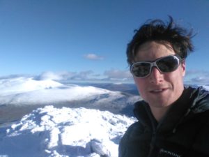 Alex Kendall is a Winter Mountain Leader working throughout the UK and abroad, and in the office organising outdoor adventures for adult groups. He also writes articles, and so far has had a book published with Cicerone, The Snowdonia Way, a new long-distance route through North Wales. He lives in Cumbria and runs up hills whenever possible.