


Noone has commented on this article yet.
Filed under:
Mountain Running, Mountaineering, Navigation, Scrambling, Ski Touring, Walking / Trekking,Being able to calculate distance is an important skill in poor visibility or when an objective is not obvious.
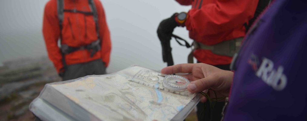
Measuring on a map
There are various ways of doing this, but it is probably easiest by using the compass. Most designs will have a scale printed on the base-plate as well as inches or millimetres along the side, and these can be related to the printed map scale and used to calculate distance quite accurately.
Timing
Knowing your speed across certain types of terrain is important when estimating distance travelled, and a good guideline is to use an average person’s walking speed. This is obviously subjective, but can be tweaked to suit most people and terrain.
An average person walks at five kilometres (three miles) per hour. This can be further subdivided into how long it takes to walk 100 metres, for example, and this takes 1.2 minutes. Thus, if you had to walk for 500 metres on the flat, it would take you six minutes to complete the distance.
There is also ascent to consider. A reasonable pace would be to ascend a 10 metre (30ft) contour line every 30 seconds. Thus, if you had to walk 500 metres along and up 60 metres, the time taken would be 6 minutes plus 6 x 30 seconds = 3 minutes, thus 9 minutes overall. Note that taken over a full day, one minute per 10 metre contour line may be more accurate. Contours in descent are generally ignored unless the going gets steep, requiring you to zigzag down, and you might then add 20 seconds per contour depending upon conditions.
Obviously, all this will change when a variety of other factors are introduced. Terrain, weather, load carried, using crampons, tiredness and the state of the rest of the group will all have relevance. You may find that, on a good day when not carrying much, you can move along at six kilometres per hour. Another time, with a heavy load, going uphill in snow at the end of a long day, you may be down to two kilometres per hour. Knowing what speed you are moving at is the key to getting the final calculation correct. The diagram below sets out speed in kilometres against distance, with the result in minutes. This is a useful thing to copy out, laminate and have with you to avoid needing to do calculations on the move when you also have to concentrate on other things.
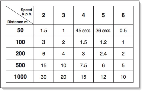
A timing chart
Pacing
This is having a known amount of double paces for 100 metres, or 100 yards. If you know how many you take on the flat – for most people this will be between 60 and 70 – if you have to walk, say, 600 metres in poor visibility then you will always know where you are.
Measure out a 100-metre, or yard, line on the flat somewhere handy. A 50-metre climbing rope could be handy for this. Now, starting with your left foot, walk along it at a normal, relaxed walking pace and count every time your right foot hits the ground. The total will be your control number for that distance. Obviously, this will change when adding various factors such as terrain, up or downhill or snow underfoot, so you need to find out how this will affect you. There is no equation for working out the difference when walking uphill for example, as some people who take 65 paces on the flat may only increase slightly to 70, others may double to 130.
When you are walking more than 100 metres or yards, always count to your maximum number, 65 for example, and then start at 0 again. Don’t be tempted to keep counting into the hundreds or you will lose count. This is where the counter on your compass, or toggles on your lanyard, will come in handy. At the end of each 100 metre or yard section, click the counter up one, or pull a toggle down, and start at zero again. You can then check the counter display, or count the toggles, to check how far you have travelled.
Words: Pete Hill Pictures: Pete Hill, Chris Kempster