


Noone has commented on this article yet.
Filed under:
Features, Great British Mountain Days, MountaineeringEvery February I am pulled northwards, away from my home in Pembrokeshire, to the allure of the Scottish Highlands wearing their winter clothes. This is despite the fact that the clothing frequently varies from a coat of beautiful frozen white snow and ice to a rag tag sprinkling of murky slush. It has to be said that winter mountaineering in ‘Scottish conditions’ is definitely not for the faint-hearted. The short days and bitterly cold arctic weather systems can create a vicious battle against the elements. For me however, the joy of testing my skills, judgement, fitness and experience far outweigh the heavy rucksack, the long approach, the ‘hot aches’, wet underwear and the ever-changeable weather.
The quality of Scotland’s mountaineering routes combined with its long and influential climbing history has given me many rich and rewarding experiences and the Great British Day Out described here is right up in my favourite list. It is one of Scotland’s best, being one of the top 10 most popular winter scrambles/climbs in the UK, as measured by entries in one UK climbing website. It stands above hundreds of ‘3-star’ winter routes of all grades spread throughout Scotland and is one of only 50 routes that have ‘4-star’ status, which means that it ranks alongside the best in the world.
The route is Curved Ridge, a wonderful line on one of Scotland’s most distinctive and imposing mountains. The Buachaille, or more correctly Buachaille Etive Mor, is a great pyramid of red/pink rhyolite that rises high above the vast and empty Rannoch Moor. The translation literally means the ‘Herdsman of Etive’ and it guards the eastern entrance to Glencoe valley. It is possibly the most photographed mountain in the UK and has the accolade of having appeared in the James Bond film ‘Skyfall’.
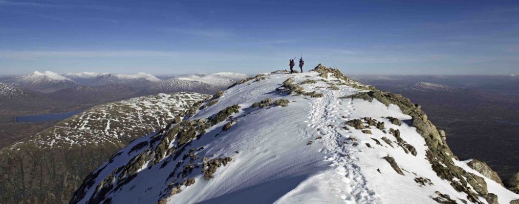
First climbed by G.T. Glover and R.G. Napier on the 11th April 1898, Curved Ridge forms the left wall of ‘Easy Gully’ and heads directly for the Buachaille’s northern summit – the Munro, Stob Dearg (1,021m). It then continues along a sinuous summit ridge with the slopes on one side dropping into Glen Etive and on the other side the steep slopes overlook the mountain pass of Lairig Gartain.
In summer conditions, the route is 240m of tricky scrambling that requires ropes and some climbing skills, although some summer scrambling bloggers seem to think it easier. When the weather is good, it is a route to be savoured by climbing slowly, but a fast and efficient ascent in summer or winter is also great preparation for an alpine trip. Between November and March the route becomes a grade 2 or 3 winter route depending, of course, on the amount of snow and ice. It is usually climbable in almost any conditions, but is best (harder) when it is plastered in snow. One of the advantages of the route is that it is sheltered from the prevailing south west wind, but this is also a disadvantage because when the weather is poor, especially towards the end of a week, then you may find a lot of instructional courses climbing it as the highlight of their course.
On the morning of our ascent we reviewed the avalanche forecast and on the map coloured the potentially hazardous slopes with a permanent marker pen and drew an arrow showing the direction of the prevailing wind. This doesn’t mean that all the uncoloured slopes are safe, but it does remind me – especially when I am tired on descents and may decide to take a short cut – where the danger areas are. I also put important compass bearings onto the map to save time and reduce the chances of mistakes if the weather and visibility become poor later in the day.
Below zero
The weather forecast for the day of our ascent was for the freezing levels to remain below the summit and the wind to be light, strengthening to force 3 or 4 from the south west later in the day. We had prepared our rucksacks the night before (my memory is appalling so I lay all my kit out by the side of my rucksack and pack in the morning) and with a good forecast we set off early to avoid the crowds. We parked in a small layby at Altnfeadh, on the A82, and put on just enough clothes to remove the chill, and shouldered our packs.
The hardest part about climbing ‘Curved Ridge’ is probably finding the start of it, because once you are up close to the ridges, walls, and buttresses of the east face, it becomes very confusing. In poor visibility, it can be very difficult to find the start, and good navigation skills are vital. If it is your first time on the Buachaille it is a good idea to drive a mile or so down Glen Etive to spy out the route and the approach to this complicated face.
With my ice axe down my back for easy access and wearing lightweight gloves that were warm enough for most situations, we set off along the frozen track that heads towards the white Lagangarbh Cottage and crosses the small Coupall River. Soon after the cottage, a left fork leads to a traverse under the North East Face of Stob Dearg, with its plethora of climbs ascended by the ‘greats’ of Scottish mountaineering history. The path soon crosses a boulder slope and after about 1.5km (40 minutes) it passes an obvious large gash called the Great Gully. Don’t linger here because avalanches have occurred in the area of Great Gully and Crowberry Basin that are above the track.
At this point, it is possible to take a short cut following the lower easy part of North Ridge with some straightforward scrambling, but that should not be underestimated as a slip will send you tumbling a long way down the mountainside. Alternatively, carry on until you reach a feature known as the Water Slab (actually past the start of Curved Ridge) and turn sharp right to continue steeply uphill, left of the Water Slab and over a scree slope. Higher up, there is a tricky rightwards step, with steep ground below that leads into a basin where the bottom of Easy Gully opens out into a small bowl beneath the start of Crowberry Ridge. From here, there are two curving ridges sweeping upwards underneath Crowberry Ridge and Rannoch Wall – Curved Ridge is the left hand one. If the snow conditions are good, it is likely that there will be a track to the base of the ridge, grid reference 227546 (90 minutes from the car).
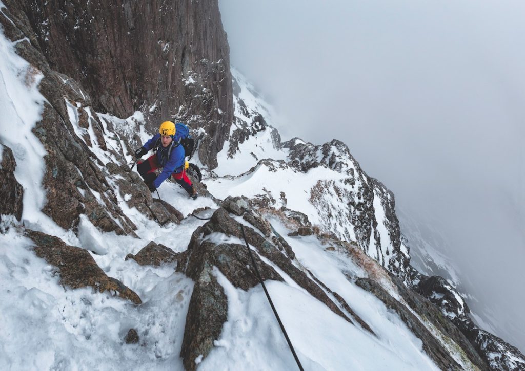
The crest of the ridge can be gained directly from its base, but we climbed a short steep icefall on the right side to gain the bottom of Easy Gully. A belay on the right hand side and a short traverse left soon led us back onto the ridge. The route now stays on the crest for a long way until an obvious snow ridge returns rightwards across the top of Easy Gully and then traverses a large steep snow slope to gain the exit gully. We climbed over blocks, ledges and short slabs with mostly solid rock, using our axes on small rock edges and sometimes twisted into cracks. The steepness and exposure increases the higher you get and the rock architecture surrounding the ridge is magnificent.
We came across a few short tricky steps where axes and crampons have difficulty finding a good purchase, but they are short lived and there are usually spacious belays stances above and below each one. Some of the difficulties can be avoided by short traverses, usually on the right hand side of the ridge, but staying on the crest is more sporting. Winter climbing skills are required and you must think carefully about where you belay so that your partner is not going to be showered by debris knocked down by the leader. For the same cunning reason, it is a good idea to give any teams ahead of you some clear ground.
Where the ridge starts to level out it turns rightwards and a cairn is sometimes discernible when the snow is not too deep. There is now a choice of routes to the summit. Both head across the steep snow slopes towards the obvious gully in the gap between Crowberry Tower and Stob Dearg. Take care crossing this slope because there have been some serious avalanche accidents; when in doubt, climb it in pitches rather than moving together. After crossing the snow slope, the easiest route follows the right hand side of the obvious rightwards slanting gully. At its top, a short leftward trending gully and easy scrambling leads to the summit. Crowberry Tower is a superb short, but tricky, detour that spirals from the col around the tower to emerge atop a small exposed platform with vertical drops on all sides. The view from here over Rannoch Moor and Glen Etive is one of the best in Scotland. From the top of the tower reverse the route to the col between the tower and the main mountain face and rejoin the route to the summit.
View from the top
Finally, we sat on the summit and enjoyed the 360-degree view, smug in the satisfaction of a great climb completed. We could relax, but only for a moment, as soon we had to switch our diligent ‘mountain brains’ back on. The summit of any mountain is only half way and mountain climbing is not over until the calorifically-challenged lady is singing and you are safe at the bottom. The visibility was coming and going and the ground was completely covered in snow so we sat and reviewed our planned descent before setting off. We were a little bit concerned about the descent down the north-facing Coire na Tulaich and decided that we would lower one of us into the gully on a rope and see what the snow was like. This descent can be very serious when the snow is rock hard or when avalanche conditions prevail. If we had any doubt, we would descend the safer but longer and more complicated North Ridge on the corrie’s west (left) side and re-enter the gully much lower down.
As we approached the descent, we met some experienced walkers who had just ascended the gully and had kicked some deep footsteps up the side of the slope. They reckoned it was safe, but despite their assessment we still decided to lower in and have a look for ourselves. The line of footsteps followed a safe line of ascent close to the rocks, the slope had no telltale signs of wind slab and it all seemed safe. We didn’t descend with the rope on as that usually means a ‘one off, all off mentality’; instead, we soloed at our own speeds facing into the slope until it became a comfortable angle for us to walk facing out. There are many variations as you get closer to the bottom of the gully and if there is a lot of snow and the slopes above are stable then continue down the gully. If in doubt stay higher on the left side until the path is found. Follow the path back to the car, with the knowledge that you’ve just completed one of Scotland’s finest winter routes.
THE KNOWLEDGE
Experience and fitness
On top of the usual skills of winter walking, such as navigation and avalanche assessment, you will need experience of at least grade 2 winter climbing. The ability to create belays and understand how to move together safely when the terrain becomes easier is essential.
What to pack
50L rucksack, winter boots, warm trousers, three layers, small duvet jacket or extra fleece, balaclava or fleece hat, waterproof jacket and trousers, ski goggles, 3 x climbing gloves (I change them frequently for a dry pair), mitts for belaying. Lightweight 4-person survival shelter, food and drink. Crampons, two ice axes (I have climbed it with one axe, occasionally borrowing another one from my partner for a few difficult moves, but most times I have taken two), harness, belay device, single rope, helmet, 4-6 240cm slings, 6 long extenders, 1 set of wires and a few medium cams.
Parking
Park carefully and considerately to allow lots of cars in a layby on the A82 (Grid ref 221563).
Where to stay
There are many bunkhouses, hotels and B&Bs to stay in. My favourite place is Inchree Chalets (www.inchree.co.uk) self catering and hostel-type rooms with a lovely bar/restaurant
Guidebooks and Maps
OS Outdoor Leisure 38 – Ben Nevis & Glencoe. 1:25,000
‘Scottish Winter Climbs’, Scottish Mountaineering Club Guide, ‘Scotland’s Mountain Ridges’ by Dan Bailey
Useful phone numbers and addresses
www.sais.gov.uk
www.metoffice.gov.uk/public/weather/mountain-forecast
www.mwis.org.uk/
Words and images: Alun Richardson